
Popular Pages
Today's:
- Information for Authors
- Submit Your Papers for ICASSP 2026!
- IEEE Transactions on Information Forensics and Security
- (ASRU 2025) 2025 IEEE Automatic Speech Recognition and Understanding Workshop
- (ICME 2026) 2026 IEEE International Conference on Multimedia and Expo
- Submit a Manuscript
- Information for Authors OJSP
- Information for Authors-SPL
- IEEE Signal Processing Letters
- Membership
- (ICASSP 2026) 2026 IEEE International Conference on Acoustics, Speech, and Signal Processing
- (CAI 2026) IEEE Conference on Artificial Intelligence 2026
- IEEE Transactions on Image Processing
- Unified EDICS
- IEEE Transactions on Signal Processing
All time:
- Information for Authors
- Submit a Manuscript
- IEEE Transactions on Image Processing
- IEEE Transactions on Information Forensics and Security
- IEEE Transactions on Multimedia
- IEEE Transactions on Audio, Speech and Language Processing
- IEEE Signal Processing Letters
- IEEE Transactions on Signal Processing
- Conferences & Events
- IEEE Journal of Selected Topics in Signal Processing
- Information for Authors-SPL
- Conference Call for Papers
- Signal Processing 101
- IEEE Signal Processing Magazine
- Guidelines
Last viewed:
- Information for Authors-SPL
- Information for Authors
- IEEE Transactions on Multimedia
- Inside Signal Processing Newsletter
- Call for Proposals: 2028 IEEE International Symposium on Biomedical Imaging (ISBI)
- Submit a Manuscript
- IEEE Journal of Selected Topics in Signal Processing (JSTSP) Special Series on AI in Signal & Data Science -- Toward Large Language Model (LLM) Theory and Applications
- IEEE Journal of Selected Topics in Signal Processing
- Login Error
- Publications FAQ
- (EUSIPCO 2025) 2025 European Signal Processing Conference
- SPS Webinar: Self-Supervised Coordinate Projection Network for Sparse-View Computed Tomography
- Newsletter
- Guidelines
- MLSP TC Home
What Should We Learn from IARPA’s Deep-Learning Challenge Seeks AI to Analyze Satellite Images


Top Reasons to Join SPS Today!
1. IEEE Signal Processing Magazine
2. Signal Processing Digital Library*
3. Inside Signal Processing Newsletter
4. SPS Resource Center
5. Career advancement & recognition
6. Discounts on conferences and publications
7. Professional networking
8. Communities for students, young professionals, and women
9. Volunteer opportunities
10. Coming soon! PDH/CEU credits
Click here to learn more.
News and Resources for Members of the IEEE Signal Processing Society
What Should We Learn from IARPA’s Deep-Learning Challenge Seeks AI to Analyze Satellite Images
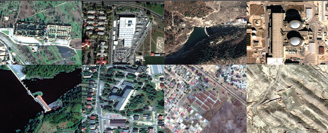
Spy satellites and their commercial cousins orbit Earth like a swarm of space paparazzi, capturing tens of terabytes of images every day. The deluge of satellite imagery leaves U.S. intelligence agencies with the world’s biggest case of FOMO—“fear of missing out”—because human analysts can sift through only so many images to spot a new nuclear enrichment facility or missiles being trucked to different locations. That’s why U.S. intelligence officials have sponsored an artificial-intelligence challenge to automatically identify objects of interest in satellite images.
Since July, competitors have trained machinelearning algorithms on one of the world’s largest publicly available data sets of satellite imagery—containing 1 million labeled objects, such as buildings and facilities. The data is provided by the U.S. Intelligence Advanced Research Projects Activity (IARPA). The 10 finalists will see their AI algorithms scored against a hidden data set of satellite imagery when the challenge closes at the end of December.
The agency’s goal in sponsoring the Functional Map of the World Challenge aligns with statements made by Robert Cardillo, director of the U.S. National Geospatial-Intelligence Agency, who has pushed for AI solutions that can automate 75 percent of the workload currently performed by humans analyzing satellite images.
Their best algorithm produced results that were verified by humans as 98 percent accurate. The algorithm took just 42 minutes to deliver readings that matched the accuracy of human analysts, whereas a traditional visual search by humans required an average of 60 hours.
Such results bode well for the IARPA challenge goal and could help establish deep learning as a necessary tool. Both governments and companies continue to launch swarms of imaging satellites to join the existing constellations peering down at Earth. The U.S. commercial satellite operator DigitalGlobe—which provided the imagery for the IARPA challenge—already captures more than 70 terabytes of raw imagery each day. Sooner, rather than later, human analysts will need all the AI help they can get.
Reference
Jeremy Hsu. WANTED: AI THAT CAN SPY. IEEE Spectrum. December, 2017, pp.12-13
SPS Social Media
- IEEE SPS Facebook Page https://www.facebook.com/ieeeSPS
- IEEE SPS X Page https://x.com/IEEEsps
- IEEE SPS Instagram Page https://www.instagram.com/ieeesps/?hl=en
- IEEE SPS LinkedIn Page https://www.linkedin.com/company/ieeesps/
- IEEE SPS YouTube Channel https://www.youtube.com/ieeeSPS
IEEE SPS Educational Resources
IEEE SPS Resource Center

IEEE SPS YouTube Channel